Validate your BIM models against actual site conditions. Bridge design intent with execution reality.
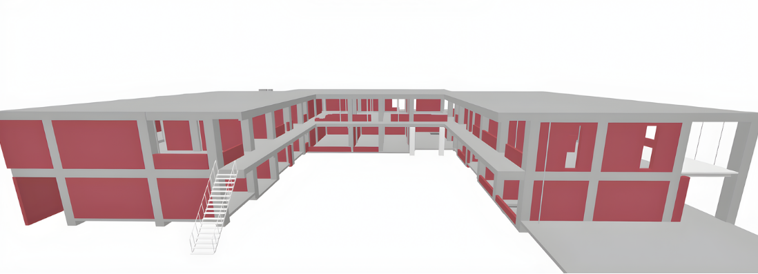
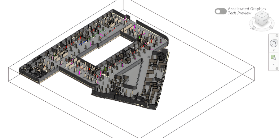
Millimeter-Accurate As-Builts
Reverse-engineer laser scans into models that mirror physical reality.
Design and Execution
Stay Aligned.
BIM Solutions.
From raw capture to coordinated intelligence—we bridge the gap between design and reality.
Document
the ground truth.
Start every project with 100% certainty. We convert raw site data into 3D models accurate to ±5 mm, ensuring your project baseline is based on fact, not outdated drawings.
Build it digitally
before you mobilize.
Eliminate guesswork before the first brick is laid. We convert 2D plans into smart 3D systems to ensure architecture and engineering work in perfect harmony.
Verify execution
in real-time.
Stop rework before it happens. By overlaying your design onto live site captures, we flag structural deviations instantly.
Zero conflicts.
Zero rework.
Identify and resolve system collisions in the office—not on the job site. Protect your project margins from field errors.
A Single Source.
For Every Team.
One reality capture flight feeds every stakeholder with validated site data.
Design Teams
Validate that coordination efforts translated to execution.
General Contractors
Track progress against model elements. Prove execution matched approved designs.
MEP Contractors
Install with confidence. Know structural elements are exactly where they should be.
Quality Teams
Validate dimensional tolerances without manual tape measurements. Scan once, verify all assets.
Facility Managers
Receive as-built models that match reality perfectly. Maintenance, renovations, and operations start with accurate data.
Owners
Accept handover with absolute confidence. Know unequivocally that what was designed is what was delivered.
Works With Your
BIM Workflow.
Seamlessly import/export Revit files, point clouds, and IFC models without changing a single step in your current workflow.
Frequently Asked Questions
Related Use Cases
Real-world examples of this solution in action.
Guides
How it works, what it costs, and what to ask before you start.
- As-Built vs As-Planned: Model Deviation First, Programme Dates SecondCheck the built structure against the design model with scans and drone surveys, read deviation heatmaps, close errors, then test dates against the programme.
- BIM Coordination During Construction: Keeping the Model in Step with the SiteHow to keep the federated BIM model aligned with installed work using scans, drone and 360° captures, field-conflict checks and a weekly site routine.
- Laser Scanning in Construction: Methods, Accuracy and When It Is Worth ItHow laser scanning works, how terrestrial, mobile and aerial LiDAR differ, how scans compare with photogrammetry and 360 capture, and when to scan.
- Reality Capture and BIM: How Site Data and the Model Work TogetherHow reality capture and BIM differ, how scans and drone data feed the model and check the build, and the setup that makes the two line up.
- What Is Scan to BIM? The Process, LOD and Accuracy Specs, Deliverables and How to Scope ItWhat Scan to BIM is, how a laser scan becomes a BIM model, how LOD and level of accuracy are specified, what you receive and how to scope a project.
- BIM in Construction: Using the Model on Site, During the Build and at HandoverHow to use BIM after design: getting the model to the field, running the build against it, keeping it current and handing over a model an owner can use.
- What Is a Point Cloud? Capture, Accuracy, Formats and Use on Live ProjectsWhat a point cloud is, how laser scanners, drones and phones capture one, what density and accuracy mean, which file formats to ask for and how it becomes BIM.
- Photogrammetry vs LiDAR: Which Should Your Project Use?When drone photogrammetry is enough and when aerial or terrestrial LiDAR is worth paying for, compared on vegetation, accuracy, cost and outputs by use case.
Scan to BIM that catches the gap between design and reality.
Validate your BIM models against actual site conditions. Bridge design intent with execution reality.
Millimeter-Accurate As-Builts
Point cloud to BIM conversion at LOD 300–400. We reverse-engineer raw laser scans and drone point clouds into intelligent as-built BIM models that mirror the exact physical reality of your site.
When Design and Execution Stay Aligned,
Coordination Becomes Proactive.
Our End-to-End
BIM Solutions.
From point cloud to BIM model — LOD 300 to LOD 400 — we provide the tools to bridge the gap between as-built reality and design intent.
Document
the ground truth.
Start every project with 100% certainty. We convert raw site data into 3D models accurate to ±5 mm, ensuring your project baseline is based on fact, not outdated drawings.
Build it digitally
before you mobilize.
Eliminate guesswork before the first brick is laid. We convert 2D plans into smart 3D systems to ensure architecture and engineering work in perfect harmony.
Verify execution
in real-time.
Stop rework before it happens. By overlaying your design onto live site captures, we flag structural deviations instantly so they can be corrected immediately.
Zero conflicts.
Zero rework.
Identify and resolve system collisions in the office—not on the job site. We find every pipe and beam conflict digitally to protect your project margins.
A Single Source of Truth.
For Every Stakeholder.
From design to handover, ensure every team operates from the same validated reality. Eliminate friction, prevent compounding errors, and build with absolute certainty.
Design Teams
Validate that coordination efforts translated to execution. See which design decisions held up onsite.
General Contractors
Track progress against model elements. Prove execution matched approved designs for billing and compliance.
MEP Contractors
Install with confidence. Know structural elements are where the model says they are—no surprises.
Quality Teams
Validate dimensional tolerances without manual tape measurements. Scan once, verify everything.
Facility Managers
Receive as-built models that match reality perfectly. Maintenance, renovations, and operations start with accurate data.
Clients & Owners
Accept handover with absolute confidence. Know unequivocally that what was designed is what was delivered.
Works With Your
BIM Workflow.
YelloSKYE integrates seamlessly with the modeling tools and coordination platforms you already rely on. No need to abandon your existing processes.
Seamless Platform Integrations
Scan to BIM — common questions.
What is scan to BIM?+
Scan to BIM converts reality capture data — from drones, LiDAR, or 360° cameras — into accurate parametric BIM models. These as-built models reflect the actual constructed state, enabling clash detection, renovation planning, and handover documentation.
How does YelloSKYE create as-built BIM models?+
YelloSKYE captures the site using drone photogrammetry or LiDAR to generate a dense point cloud. This is modeled into LOD 300–400 BIM elements, aligned to the project's coordinate system, and overlaid against the design model to reveal deviations and clashes.
What is clash detection in scan to BIM?+
Clash detection compares the as-built BIM model (what was actually constructed) against the design BIM model (what was planned). YelloSKYE highlights discrepancies — structural elements out of position, MEP conflicts, and construction deviations — before they become costly remediation issues.
What LOD can YelloSKYE deliver?+
YelloSKYE delivers scan-to-BIM from LOD 200 (schematic massing) up to LOD 400 (fabrication-level detail) depending on capture method and project requirements. Most renovation and as-built verification projects are delivered at LOD 300–350.
Related Use Cases
Real-world examples of this solution in action.
Guides
How it works, what it costs, and what to ask before you start.
- As-Built vs As-Planned: Model Deviation First, Programme Dates SecondCheck the built structure against the design model with scans and drone surveys, read deviation heatmaps, close errors, then test dates against the programme.
- BIM Coordination During Construction: Keeping the Model in Step with the SiteHow to keep the federated BIM model aligned with installed work using scans, drone and 360° captures, field-conflict checks and a weekly site routine.
- Laser Scanning in Construction: Methods, Accuracy and When It Is Worth ItHow laser scanning works, how terrestrial, mobile and aerial LiDAR differ, how scans compare with photogrammetry and 360 capture, and when to scan.
- Reality Capture and BIM: How Site Data and the Model Work TogetherHow reality capture and BIM differ, how scans and drone data feed the model and check the build, and the setup that makes the two line up.
- What Is Scan to BIM? The Process, LOD and Accuracy Specs, Deliverables and How to Scope ItWhat Scan to BIM is, how a laser scan becomes a BIM model, how LOD and level of accuracy are specified, what you receive and how to scope a project.
- BIM in Construction: Using the Model on Site, During the Build and at HandoverHow to use BIM after design: getting the model to the field, running the build against it, keeping it current and handing over a model an owner can use.
- What Is a Point Cloud? Capture, Accuracy, Formats and Use on Live ProjectsWhat a point cloud is, how laser scanners, drones and phones capture one, what density and accuracy mean, which file formats to ask for and how it becomes BIM.
- Photogrammetry vs LiDAR: Which Should Your Project Use?When drone photogrammetry is enough and when aerial or terrestrial LiDAR is worth paying for, compared on vegetation, accuracy, cost and outputs by use case.



