Drone Corridor Mapping: How to Survey Roads, Railways, Pipelines and Power Routes
By Kush Agarwal, President and CEO, YelloSKYE. Published .
Executive Summary
- The Question: How do you map a road, railway, pipeline or power route that runs for tens of kilometres but is only a few hundred metres wide?
- The Answer: Fly along the alignment in parallel strips at a height that follows the terrain, spread ground control along the whole length, split the deliverables into chainage sections that match how the project is managed, and repeat the same plan for every later survey so the results can be compared.
- The YelloSKYE Angle: Survey IQ flies terrain-following corridor missions and publishes georeferenced orthomosaics and terrain models to the DEX platform, where progress and volumes are read section by section along the route.
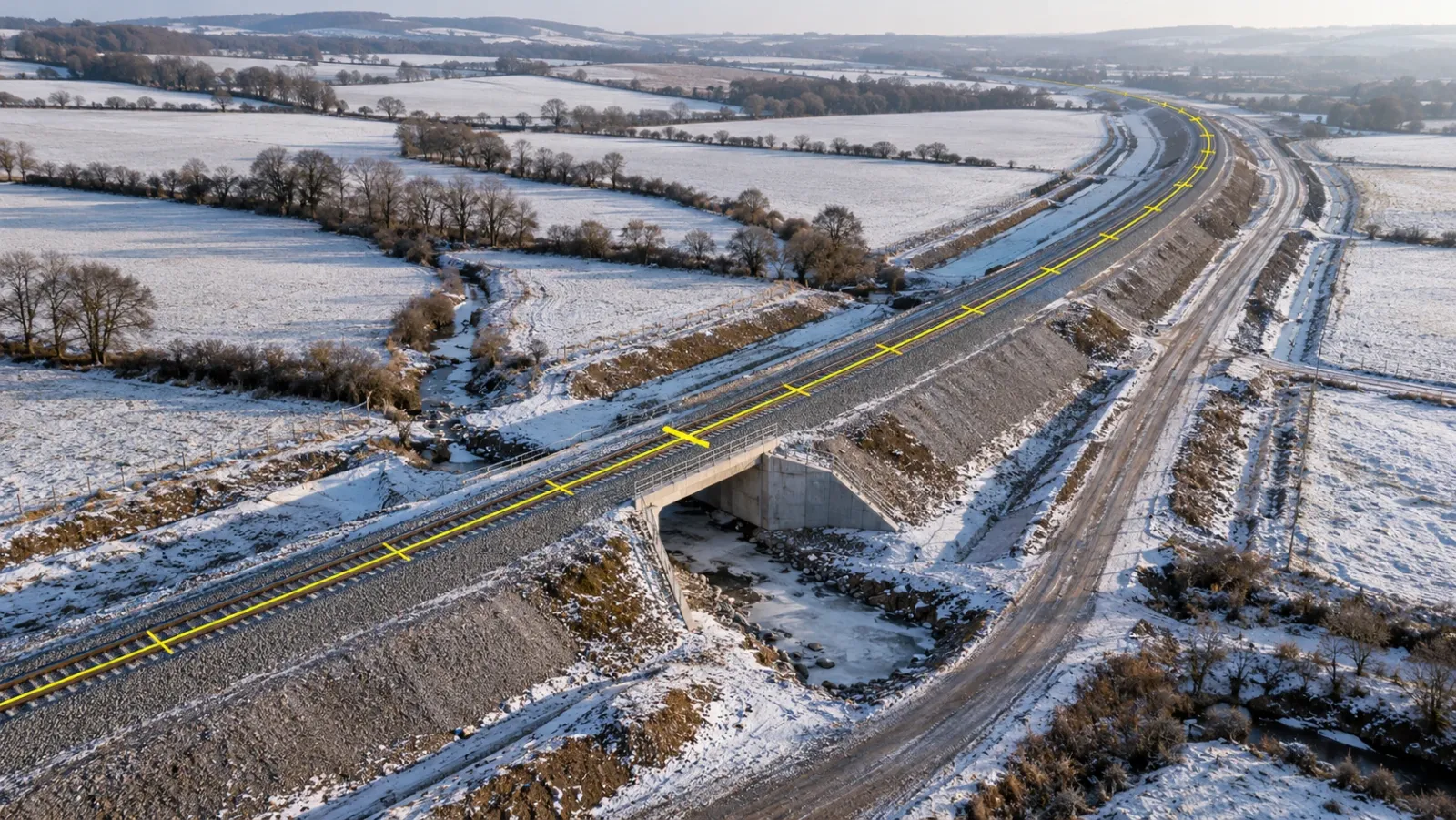
Drone corridor mapping is the survey of a long, narrow site, such as a road, railway, pipeline, canal or power route, by flying a drone along the alignment and processing the data into orthomosaics, terrain models and point clouds that cover the whole length in one coordinate system. It replaces the slowest part of a linear survey, walking or driving the route to measure it point by point, with continuous coverage captured in days.
Long, thin sites behave differently from compact ones. Errors build up along their length, the terrain changes from one end to the other, and the project is usually managed in sections rather than as a single area. At YelloSKYE, corridor work runs through Survey IQ, our land survey solution. This guide covers how corridor flights are planned, how control keeps a long model straight, how to divide deliverables so people can use them, and how to set up repeat surveys that compare cleanly.
Why a corridor is not just a long site
A 300-hectare development parcel and a 300-hectare road corridor need roughly the same number of images. They do not need the same survey design.
- Geometry. A compact block of images supports itself from every side. A strip only a few images wide has little to hold it in shape, so without enough control the model can bend, twist or drift in height along its length.
- Changing terrain. A corridor may climb out of a valley, cross a ridge and drop to a river. A fixed flight height gives a different image resolution at each point.
- Many owners and authorities. The route crosses private land, public roads, rivers and sometimes other infrastructure, each with its own access arrangements.
- Airspace. A long route is more likely to pass near airports, built-up areas or restricted zones, and to need flights beyond visual line of sight.
- How the project thinks. Engineers, contractors and owners talk in chainage, kilometre posts and contract sections, not in map tiles.
Every decision below follows from these five points.
Flight strategies for long, narrow sites
Parallel strips sized to the mapped width
Plan the number of flight lines from the width that must be mapped, not the width of the asset. A pipeline easement might be covered in two or three lines. A motorway with embankments, junctions and drainage outfalls might need five or more. Keep sidelap generous at the outer lines, where the model is weakest.
Follow the terrain
Terrain-following flight keeps the drone at a steady height above the ground rather than above the take-off point, so image resolution and overlap stay consistent along the route. On a corridor that climbs and falls, it is the difference between an even dataset and one with blurred or gappy sections.
Break the route into flight blocks
Split the corridor into blocks that one battery or one flight can complete, with an overlap of several image rows between neighbouring blocks. Plan block boundaries around access points, so the crew can move along the route efficiently, and avoid putting a boundary across a bridge, junction or other complex feature.
Choose the aircraft for the length
| Corridor | Typical mapped width | Usual aircraft | Sensor |
|---|---|---|---|
| Pipeline or cable route | Narrow easement plus working strip | Multirotor for short routes, fixed-wing or VTOL for long ones | Camera; LiDAR where vegetation hides the ground |
| Road or motorway | Carriageway plus embankments, junctions and side roads | Multirotor or VTOL | Camera, with LiDAR for terrain under cover |
| Railway | Formation plus cuttings, embankments and structures | Multirotor near live lines, VTOL on long open sections | Camera; close-range work at structures |
| Power route | Right of way plus clearance zone | VTOL or multirotor | LiDAR for conductor and vegetation clearance |
| Canal or river | Channel plus banks and flood margin | Multirotor or VTOL | Camera; LiDAR on wooded banks |
Multirotors are easy to launch anywhere and handle short sections, structures and crossings well. Fixed-wing and VTOL aircraft cover far more distance per flight, which matters once a route runs beyond a few kilometres.
Permissions take programme time
Long corridors are the type of survey most likely to need flights beyond visual line of sight, flights over roads or railways and access across many properties. Each country writes its own rules through its aviation authority; the UAE's GCAA, the UK's CAA and America's FAA are three examples, and their conditions for long-range flight are not the same. Rail and highway operators often add their own requirements near live traffic. Build the approvals into the programme early; they are often the longest lead item in a corridor survey.
Control along the corridor
Control is what keeps a long model straight and in the right place. Our guide to ground control points explains target placement in detail; for corridors, three principles matter most.
Spread it along the whole length. Control placed only at the ends of a corridor leaves the middle free to sag. Points staggered on alternate sides of the alignment at regular intervals, with additions at bends, gradient changes and crossings, stop the model from bending.
Keep check points separate. Measure extra points that are not used in processing and compare them with the finished model. On a corridor, spread them evenly along the route, because errors tend to grow with distance from the nearest control.
Use one reference frame for the whole route. Every block, every later survey and every design file must share the same coordinate system and height datum. Over long distances there is a further detail: the difference between grid distances on a map projection and true ground distances can become noticeable. Many long infrastructure projects define a project-specific projection to keep that difference small. Agree with the design team which one is in use before the first flight.
RTK or PPK positioning on the drone reduces the amount of control needed and is especially useful on long routes where reaching the ground is slow. It does not remove the need for check points, and on very long corridors a consistent base station or correction network matters as much as the drone itself.
Splitting the deliverables
A single orthomosaic of a 40-kilometre route is too large to open and too awkward to use. Divide the deliverables in the way the project is managed.
| Deliverable | How to segment it | Who uses it |
|---|---|---|
| Orthomosaic | Tiles or sheets by chainage range, overlapping slightly, named by start and end chainage | Site teams, designers, land and right-of-way teams |
| Terrain model and contours | Same chainage sections as the orthomosaic | Design, drainage and earthwork teams |
| Long sections and cross sections | Along the centreline, with cross sections at fixed intervals | Highway, rail and pipeline engineers |
| Volumes | By contract section or earthwork zone | Commercial teams, for progress payment claims |
| Point cloud | Blocks aligned to the chainage sections | Specialists, BIM and detailed design teams |
| Index map | One overview of the whole route showing every section | Everyone, as the way into the dataset |
Two rules prevent most confusion. Name every file by chainage, not by flight number. And match section breaks to the contract's section boundaries wherever possible, so a commercial team can read the volume for a section straight from the survey without re-cutting the data.
Repeat surveys: making each flight comparable
On a construction project, the first corridor survey is a baseline. The value comes from the surveys that follow.
Keep the plan fixed
Fly the same blocks, at the same height, with the same overlap and the same control every time. Changing the flight plan between surveys introduces differences that look like change on the ground but are not.
Measure change section by section
With comparable surveys, the team can calculate cut and fill for each section, track embankment and cutting progress against the design, and confirm completed lengths before a payment claim is approved. In our earthwork volumetric analytics use case, a highway team went from waiting two weeks for each volume survey to receiving results within hours, and the monthly arguments over earthwork claims stopped.
Watch the right of way
Repeat orthomosaics show clearing progress, unauthorised encroachment, temporary works outside the permitted boundary and damage to neighbouring land, each tied to a date and a chainage. Our linear corridor mapping use case covers this kind of right-of-way tracking on highways, pipelines and railways.
Fly after events
Floods, landslips and storms change corridors suddenly. A flight after the event, compared with the last routine survey, shows exactly what moved and where. The same terrain model supports drainage design along the route, as in our flood risk and drainage planning use case.
What each type of corridor needs
Roads. Surface levels and drainage matter most. Plan cross sections at intervals that suit the design, and capture junctions and side roads in full. For existing roads, a separate condition survey records surface defects.
Railways. Work near live track brings the strictest access rules. The formation, cuttings, embankments and structures are the core of the survey; ballast and stockpile volumes are often added.
Pipelines. The working strip and easement are narrow, but terrain, watercourses and crossings dominate the design. During construction, the open trench is the moment to record what is laid; our guide to utility as-built mapping covers that capture.
Power routes. Clearance between conductors, vegetation and the ground is the key measurement, which is why LiDAR is common. Close inspection of towers and fittings is a separate task, covered in our guide to power line drone inspection.
For the terrain products themselves (DTM, contours, breaklines), see our guide to the drone topographic survey; corridor mapping uses the same outputs, cut into sections.
How YelloSKYE maps corridors
Survey IQ flies terrain-following missions sized to the width of each corridor, with ground control along the route, and processes the imagery into georeferenced orthomosaics and terrain models covering the full length. Our land survey drones cover 50 to 200 hectares per day, and on corridor projects survey data has been delivered 5× faster than conventional survey cycles.
Each survey is published to the DEX platform, where data is organised by chainage so leadership and site teams can compare the planned alignment with what has actually been built, section by section. Because every flight sits on the same timeline with the design files and earlier surveys, the corridor builds up a dated record that supports progress payment claims, right-of-way reporting and authority reviews.
Corridor mapping checklist
- Define the mapped width, not just the asset width, and plan flight lines from it.
- Use terrain-following flight and divide the route into blocks with overlap between them.
- Choose the aircraft for the route length and the sensor for the ground cover.
- Start permissions early, checking the rules of the national aviation authority and the asset operator.
- Stagger control along the full length and keep independent check points spread evenly.
- Fix one coordinate system, projection and height datum with the design team before the first flight.
- Name deliverables by chainage and align sections with contract boundaries.
- Keep the flight plan, height and control identical for every repeat survey.
Frequently asked questions
What is drone corridor mapping?
Drone corridor mapping is the survey of a long, narrow area, such as a road, railway, pipeline, canal or power route, using drones flown along the alignment. The imagery or LiDAR data is processed into orthomosaics, terrain models and point clouds that cover the full length of the route in one coordinate system.
How wide a corridor can a drone map in one pass?
It depends on flight height, camera and the sidelap needed. A narrow route such as a pipeline right of way can often be covered with two or three parallel flight lines, while a motorway or rail corridor with embankments and side roads needs more. Plan the number of lines from the width that must be mapped, not from the width of the asset itself.
How many ground control points does a corridor survey need?
There is no fixed number, but corridors need control spread along their whole length, usually staggered on alternate sides of the alignment, with extra points at the ends, at bends and at crossings. RTK or PPK positioning on the drone reduces the number required but does not remove the need for independent check points.
Do you need permission to fly a drone along a long corridor?
Usually. Long routes often require flights beyond visual line of sight, cross several land ownerships and pass through different airspace, all of which are regulated. Rules differ by country, so check with the national aviation authority (for example the FAA in the US, the CAA in the UK or the GCAA in the UAE) and allow time for permissions in the programme.
How often should a corridor be resurveyed?
Match the interval to the activity. During heavy earthworks, flights every week or two support volume and progress checks; during quieter phases, monthly or milestone-based flights are usually enough. For operating assets, an annual survey plus flights after storms, floods or reported encroachment is a common pattern.