
Key takeaways
- The Context: Land development teams need to know how a parcel behaves under rainfall before acquisition closes and before layout, grading and drainage design are locked, across residential, commercial, infrastructure and public works projects.
- The Solution: Survey IQ drone topographic surveys that generate orthomosaic maps, DEM/DTM terrain models, water flow simulation and LULC classification from a single mobilisation.
- The ROI: 5× faster survey data velocity, drainage risk verified before financial commitment, and authority-ready terrain documentation produced at the planning stage.
Drone Survey for Flood Risk Mapping Before Land Development
Before a land parcel moves into acquisition, layout, grading or infrastructure planning, teams need to understand how it behaves across elevation, slope and surface flow. Once the deal is signed, the parcel's hydrology becomes the developer's responsibility, and once road alignments and plot levels are fixed, terrain-linked revisions get expensive.
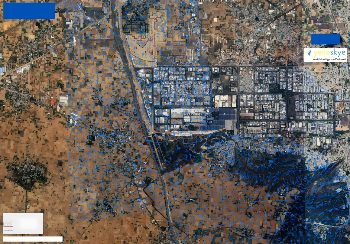
Instead of relying on legacy contour maps or desktop satellite assessments, forward-thinking developers, EPC teams and public infrastructure planners commission drone-based flood risk mapping. YelloSKYE's Survey IQ captures the parcel with a calibrated drone topographic survey and converts it into georeferenced orthomosaic maps, DEMs and DTMs. Water flow simulation on that terrain model shows exactly where water accumulates, which way it drains and which zones are at risk.
The outcome: planning teams move from broad terrain interpretation to mapped, measurable site intelligence that supports acquisition decisions, drainage design, grading strategy and approval-stage documentation.
Planning a land parcel review?
See what Survey IQ can capture before acquisition and drainage decisions are finalised.
Flood Risk and Drainage Outputs from One Drone Survey
| Survey IQ Output | What It Shows | Planning Decision It Supports |
|---|---|---|
| Orthomosaic Map | True-to-scale aerial site base | Existing land features, access routes, visible drainage paths and surrounding context |
| DEM | Surface elevation model | Slope direction, surface flow interpretation and low-lying zone review |
| DTM | Bare-earth terrain model | Drainage corridor planning, grading strategy and earthwork preparation |
| Water Flow Simulation | Surface water movement under rainfall | Accumulation zones, flow concentration points and natural drainage channels |
| LULC Classification | Impermeable surfaces, vegetation, water bodies, open ground | Runoff assumptions and where engineered drainage is needed |
| Contour Outputs | Elevation intervals across the site | Road levels, plot grading, stormwater planning and design coordination |
| Geo-Referenced Archive | Timestamped terrain record | Consultant coordination, authority submissions and internal planning review |
Engineers get the terrain outputs they need. Developers get a clear view of how drainage connects to land viability, layout feasibility, earthwork planning and project readiness.
Need terrain outputs for drainage planning?
Share your site area and planning stage. YelloSKYE can show which Survey IQ outputs fit your review.
When to Commission a Drone Survey for Flood Risk and Drainage
The highest-value moments are before money is committed and before design is locked.
| Project Stage | Why Teams Use It |
|---|---|
| Land Acquisition Due Diligence | Identify flood-prone and low-lying zones, price drainage infrastructure and negotiate parcel value before signing |
| Master Planning | Align layouts with slope direction, surface flow and natural drainage patterns |
| Infrastructure Planning | Review road levels, outfalls, stormwater corridors and grading requirements |
| Approval-Stage Coordination | Support consultant and authority discussions with mapped terrain documentation |
| Pre-Execution Planning | Give civil, earthwork and drainage teams a verified site reference before mobilisation |
For acquisition-stage reviews that also need boundary verification, buildable area and cut/fill estimates, see drone land survey for site feasibility.
The Survey IQ Flood Risk and Drainage Workflow
-
Full-Site Drone Topographic Survey: Survey IQ flies a calibrated mission across the entire parcel, capturing overlapping high-resolution imagery with embedded GPS positioning. Open land, access roads, natural contours, drainage channels and surrounding development edges are all captured in one spatially consistent dataset.
-
Orthomosaic, DEM and DTM Generation: Imagery is processed into a georeferenced orthomosaic and terrain models. The DEM encodes surface elevation at every point; the DTM strips out surface features to reveal bare earth, giving hydrological analysis the accuracy it needs.
-
Water Flow Simulation and Accumulation Mapping: Water flow simulation runs on the terrain model, tracing how surface water moves across the site under rainfall. Accumulation zones, flow concentration points and natural drainage pathways are mapped and documented before design begins.
-
LULC Classification and Drainage Feasibility: The orthomosaic is classified for land use and land cover, identifying impermeable surfaces, vegetation, water bodies and open ground, all of which shape drainage design assumptions. Combined with the flow simulation, planning teams identify zones that need engineered drainage in the master plan.
-
Drainage Corridor Planning: With a verified terrain model, teams evaluate proposed drainage routes, stormwater channels, road levels and plot grading against the actual ground before design packages move into execution.
-
Authority-Ready Terrain Documentation: Survey IQ's georeferenced orthomosaic, terrain models and LULC outputs provide a timestamped record of the site's terrain condition for internal reviews, consultant coordination and environmental clearance or drainage approval submissions.
Driving Predictability in Land Development
-
Acquisition decisions backed by verified hydrology: Flood-prone areas are identified and documented before the deal closes, so the team can price drainage infrastructure accurately, exclude high-risk zones from developable area, and negotiate with evidence in hand.
-
Drainage design grounded in real terrain: DEM/DTM outputs, flow simulation and LULC data let engineers size and position drainage against actual site conditions, not interpolated estimates from legacy topo sheets.
-
Faster survey data velocity for large parcels: Survey IQ delivers terrain intelligence 5× faster than traditional survey cycles, quickly enough to support acquisition review, layout planning, drainage design and grading decisions without extending early-stage timelines.
-
Approval documentation from the same survey: Developers exit the planning stage with authority-ready spatial documentation instead of commissioning separate surveys after the land is purchased.
Your site, in sight. When terrain shapes every downstream decision, Survey IQ gives planning teams the verified ground intelligence needed to design with clarity from day one.
Ready to Map Drainage Risk Before Design Lock-In?
See how Survey IQ produces orthomosaic, DEM/DTM, water flow and LULC outputs for flood risk and drainage planning before land development begins.