Utility As-Built Mapping: Recording Buried Services Before You Dig and Before You Backfill
By Kush Agarwal, President and CEO, YelloSKYE. Published .
Executive Summary
- The Question: How do you map buried services well enough that nobody hits them during excavation, and record new ones accurately before the trench is closed?
- The Answer: Treat it as two jobs. Before digging, combine existing records, surface evidence and field detection into a map with a stated confidence level. Before backfill, capture every new pipe, duct and cable in the open trench with controlled, georeferenced imagery, then hand the owner a record with positions, levels and attributes.
- The YelloSKYE Angle: Survey IQ flies RTK-equipped drones over ground control to record open trenches, and the DEX platform keeps each capture on a dated timeline beside the design, so the record of what lies underground outlives the project team.
Utility as-built mapping is the work of recording where buried services are: pipes, cables, ducts and drains. It happens at two moments. Before excavation, it tells the crew what is already in the ground. Before backfill, it captures what has just been laid, while it can still be seen and measured. Once a trench is closed, the record made in that short window is the only reliable evidence of what is down there.
Drones are useful for both jobs, but not in the way people sometimes assume. A drone cannot see through soil. What it can do is map surface evidence across a whole site in one flight and measure open trenches to a few centimetres. At YelloSKYE we do this through Survey IQ, our land survey solution. This guide explains how the two jobs differ, what each detection method can and cannot find, how to capture new services before they disappear, and what a record must contain to be useful to the owner years later.
Two jobs that get called "utility mapping"
The phrase covers two different tasks with different methods, different owners and different risks. Mixing them up is how gaps appear.
| Mapping existing services | Recording new services | |
|---|---|---|
| When | Before design is fixed and before any excavation | After laying and testing, before bedding and backfill |
| What you are dealing with | Services of unknown age, owner and accuracy | Services you can see, touch and measure |
| Main methods | Record searches, surface survey, electromagnetic locators, ground-penetrating radar, trial holes | Controlled drone capture, GNSS or total station shots, close-range photos or scans |
| Main risk | Striking a live service | Losing the only chance to record the service accurately |
| Who needs the output | Designers, excavation crews, the principal contractor | The asset owner, maintenance teams, future contractors |
The first job reduces uncertainty about the past. The second prevents uncertainty in the future. A project usually needs both: one at the start of groundworks, and one running alongside every trench that is opened.
What a drone can and cannot see underground
Being clear about the limits of each method stops anyone from over-trusting a pretty map.
| Method | What it finds | What it misses |
|---|---|---|
| Existing records and utility owner plans | Approximate routes of registered services | Private, abandoned and undocumented services; anything moved after the drawings were made |
| Drone survey of the surface | Covers, valve boxes, hydrants, marker posts, poles, kerb cuts, trench scars, locator paint marks across the whole site | Anything below the surface |
| Electromagnetic locator | Metallic pipes and cables, and plastic ducts fitted with tracer wire | Non-metallic pipes without tracer wire; depth readings become unreliable where services are congested |
| Ground-penetrating radar | Many non-metallic services and voids, with an indication of depth | Signal fades in wet clay and saline ground; readings need skilled interpretation |
| Trial holes (often by vacuum excavation) | Exact position, level, size and material at that point | Everything between the holes |
| Drone capture of an open trench | The full exposed run: alignment, crown levels, fittings, crossings | Services that are not exposed, or are hidden under water or bedding |
Surface evidence matters more than it seems. A line of covers, a straight patch of newer asphalt and a row of paint marks often reveal a route before anyone switches on a detector, and an orthomosaic records all of it at once as a base map for the locating team. Our guide to construction site mapping covers how that same map supports logistics and earthwork.
How much to trust a utility record
Not every line on a utility drawing deserves the same confidence. Several national standards grade utility information into quality levels: ASCE 38 in the US and PAS 128 in the UK are two well-known examples, and other countries have their own. The labels differ, but the logic is the same, rising in four steps:
- Records only. The line comes from an existing drawing or the owner's plan, and nobody has checked it on site.
- Surface features. The record has been tied to visible covers, chambers and other surface evidence.
- Detected. A locator or radar survey has traced the service and marked its likely position.
- Exposed and measured. Someone has dug down to the service, or it is lying in an open trench, and its position and level have been surveyed.
Recording the quality level against every service on the drawing is the single most useful thing a utility map can do. It tells an excavator operator whether a line is a measurement or a guess. New services captured in an open trench start life at the highest level, which is exactly why the capture is worth doing properly.
Before you dig: mapping what is already there
A practical sequence for a site with existing services:
- Collect the records. Request plans from every utility owner with assets in or near the site, and pull any private drawings from the landowner or previous occupier. Note the date and source of each.
- Fly the site. A controlled drone survey gives an orthomosaic and surface model to plot records against, and picks up the surface evidence listed above.
- Reconcile records with the surface. Where a drawn route passes nowhere near the covers that belong to it, the record is wrong or the service has moved. Flag those conflicts.
- Detect on the ground. Locating teams sweep the areas where excavation is planned, concentrating on conflicts and on routes that the records do not explain.
- Prove the critical points. Dig trial holes where the planned work crosses or runs close to a service, and survey what you find.
- Publish one map. Combine everything on the site base map, with each service labelled by owner, type and quality level, and mark exclusion zones around high-risk services such as gas, high-voltage cables and fibre trunks.
Why strike risk is worth this effort
A service strike can injure the crew, cut power, water or communications to neighbours, stop the site while the owner repairs the damage, and lead to claims that cost far more than the excavation itself. Most strikes trace back to a service that was missing from the records, sitting somewhere other than where the drawing showed it, or known to one person and not to the excavator operator. A single published map, with confidence levels and exclusion zones, deals with all three causes.
Before you backfill: recording what you install
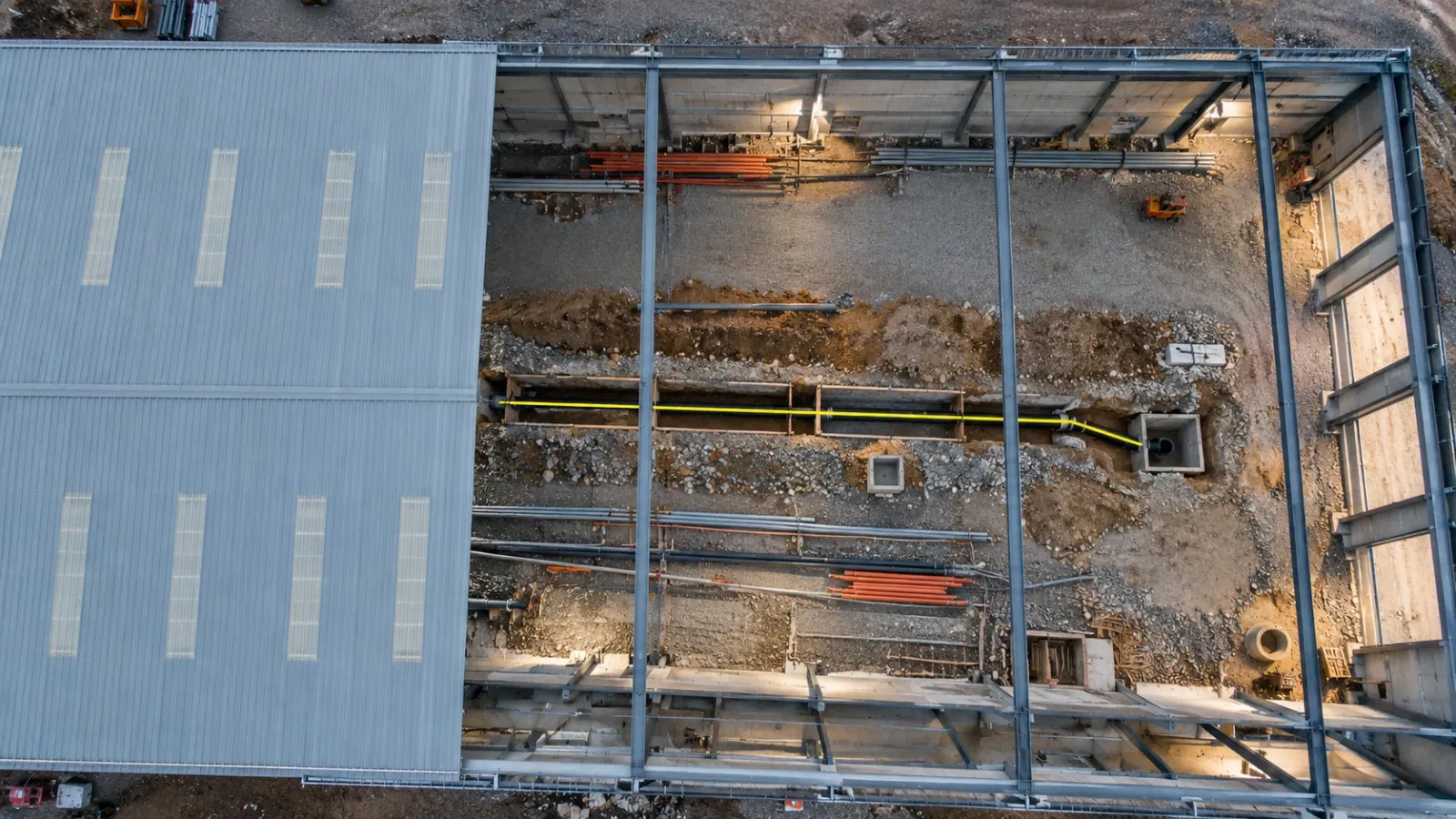
This is where drones change the most. A pipe that is lying in an open trench can be measured completely, but only for as long as the trench stays open. On most jobs that is a day or two per section before bedding, backfill and the next trade cover it.
Plan the capture into the trench programme
Agree before work starts who calls for the capture and how much notice the survey team needs. The cleanest arrangement is a hold point: a section cannot be backfilled until it has been captured and the capture has been checked. Treat it the same way as a pressure test.
Fly low and controlled
Fly at a height that resolves the pipe crown, joints and fittings clearly, usually lower than a general site survey. Use an RTK-equipped drone and ground control set outside the trench where it will not be disturbed, plus a few independent check points. Capture from more than one angle where the trench is deep or shored, so the side walls and supports do not hide the services.
Record depth properly
The number owners care about most is depth of cover, and it is the one most often guessed. A reliable method is to take the crown level of the pipe or duct from the open-trench surface model, then take the finished ground level from a later flight once the surface is reinstated. The difference is the cover depth, measured rather than assumed. The raw levels are more useful than the depth alone, because the ground surface will change again in future.
Add the detail an aerial view misses
Supplement each flight with close photographs of joints, tees, valves, duct formations and crossings with other services, each tagged to a location. Note the warning tape, tracer wire, pipe material, diameter and number of ducts. Where services are cast into a slab or run through a congested plant room, laser scanning gives a millimetre-level record that aerial capture cannot match; our guide to the as-built survey explains how scanning and drone methods divide the work.
Compare with the design while it can still be fixed
Overlay each capture on the design drawings the same day. A duct laid on the wrong side of a foundation, a fall that runs the wrong way or a crossing that is too shallow is cheap to correct with the trench open and expensive once the slab is poured.
What a utility as-built record should contain
A record that will be useful in ten years answers the same questions a future excavation crew will ask.
| Element | What to include | Typical format |
|---|---|---|
| Alignment | Centreline of every pipe, duct and cable, plus fittings, chambers and crossings | CAD (DWG or DXF) and GIS layers |
| Levels | Crown or invert levels along the run, and finished ground level above | Points with elevations, cover depth table |
| Attributes | Service type, owner, material, size, number of ducts, date laid, installer | Attribute table linked to each line |
| Visual evidence | Orthomosaic of each open section, close photographs of key features | GeoTIFF, dated and located photographs |
| 3D record | Point cloud of the open trench where complexity justifies it | LAS or LAZ |
| Confidence | Quality level for every service shown, and accuracy check results | Notes on the drawing, check point report |
| Reference frame | Coordinate system, height datum and survey control used | Survey report |
Two details cause most of the trouble later. The first is the reference frame: a record without a stated coordinate system and height datum can be misplaced by metres when someone imports it into another system. The second is the dates: a record must show when each section was captured, so that later changes can be traced.
Handing the record to owners
Owners rarely need the raw survey files on day one. What they need is a record their facilities and maintenance teams can open, search and trust when a contractor asks where the water main runs. Agree the format, attribute list and layer naming with the owner at the start of the project, not at handover, so every captured section arrives in the shape they need.
On large industrial projects, the dated visual record of services before they were enclosed is often the most valued part of the handover. Our warehouse operator handover use case describes maintenance teams using that historical record to locate services behind concrete when the facility is altered later. On sites flown weekly for progress, such as our aerial progress capture work, open trenches are often already in the imagery; the step that is usually missing is controlling, checking and attributing those captures as utility records.
How YelloSKYE approaches utility as-built mapping
For Survey IQ, the combination of RTK-GNSS drones and ground control points gives positions within 5 cm both in plan and in height, enough for open-trench records and for the base map the locating team works on. Outputs arrive as GeoTIFF orthomosaics, DXF drawings and LAS point clouds. Where services are cast into structure or crowded into plant rooms, BIM IQ adds laser scanning.
Every capture is published to the DEX platform on a dated timeline, alongside the design drawings and earlier flights, so the team can overlay the open trench on the design, measure from the browser and look back at any section months later. On pipelines and other long routes, the same approach runs along the alignment; our guide to drone corridor mapping covers how flights and control are planned for linear sites.
A drone does not replace the locating team: detection and trial holes stay essential for existing services. Its job is one accurate base map, and no new service going into the ground unrecorded.
Utility as-built mapping checklist
Before excavation
- Collect records from every utility owner and the landowner, with dates and sources.
- Fly a controlled survey of the site and plot records against surface evidence.
- Commission detection over the planned excavation areas and trial holes at critical crossings.
- Publish one services map with owner, type and quality level for every line, and mark exclusion zones.
During installation
- Write a capture hold point into the trench programme before backfill.
- Set ground control outside the trench and keep independent check points.
- Fly each open section, and photograph joints, fittings and crossings with locations.
- Overlay each capture on the design the same day and resolve deviations before backfill.
At handover
- Calculate cover depths from the open-trench and finished-surface models.
- Deliver alignment, levels, attributes, imagery and confidence levels in the owner's agreed format.
- State the coordinate system, height datum and capture dates on every record.
Frequently asked questions
Can a drone detect underground utilities?
No. Cameras and LiDAR on a drone record surfaces, so they cannot see a pipe or cable through soil, asphalt or concrete. What a drone can do is map the surface evidence of services (covers, valve boxes, marker posts, old reinstatement scars and locator paint marks) and record new services accurately while the trench is still open.
When should new utilities be surveyed?
Survey them after they are laid, jointed and tested, but before the bedding and backfill cover them. That window is often only a day or two per section, so the capture needs to be booked into the trench programme rather than requested afterwards. A later flight of the finished surface then gives the final ground level for depth-of-cover calculations.
What should a utility as-built record include?
At minimum: the horizontal alignment, the level of the pipe or duct crown, fittings, valves, chambers and crossings, the material, size and number of ducts, and the date of installation. It should state the coordinate system and height datum used, and include dated photographs of the open trench so a future reader can see what was actually laid.
Do I still need a utility locate if as-built records exist?
Yes. Records describe what was installed at one point in time, and services are often moved, abandoned or added afterwards without the drawings being updated. Treat existing records as the starting point, then confirm with electromagnetic locators, ground-penetrating radar and trial holes before excavating near them.
How accurate does a utility as-built need to be?
Most owners and specifications ask for horizontal and vertical positions within a few centimetres for new services, which an RTK-equipped drone flown with ground control can achieve over an open trench. The exact tolerance should be written into the specification before work starts, together with the coordinate system and the way accuracy will be checked.