Drone Damage Assessment: Surveying Buildings and Sites After Storms, Floods, Fires and Earthquakes
By Kush Agarwal, President and CEO, YelloSKYE. Published .
Executive Summary
- The Question: After a storm, flood, fire or earthquake, how can an owner or asset manager find out quickly and safely how badly a building or site is damaged, and record it well enough for the insurer and the repair contractor?
- The Answer: Fly the property first, before people walk it. A drone survey gives a dated, measurable record of roofs, facades and grounds within days, shows where it is safe to send inspectors, and becomes the baseline for the claim, the repair scope and the check that repairs were done.
- The YelloSKYE Angle: Inspect IQ flies RGB, thermal and LiDAR sensors over the asset and keeps each capture on one timeline in the DEX platform, so damage can be measured, compared with an earlier date and logged as findings without anyone climbing onto an unsafe structure.
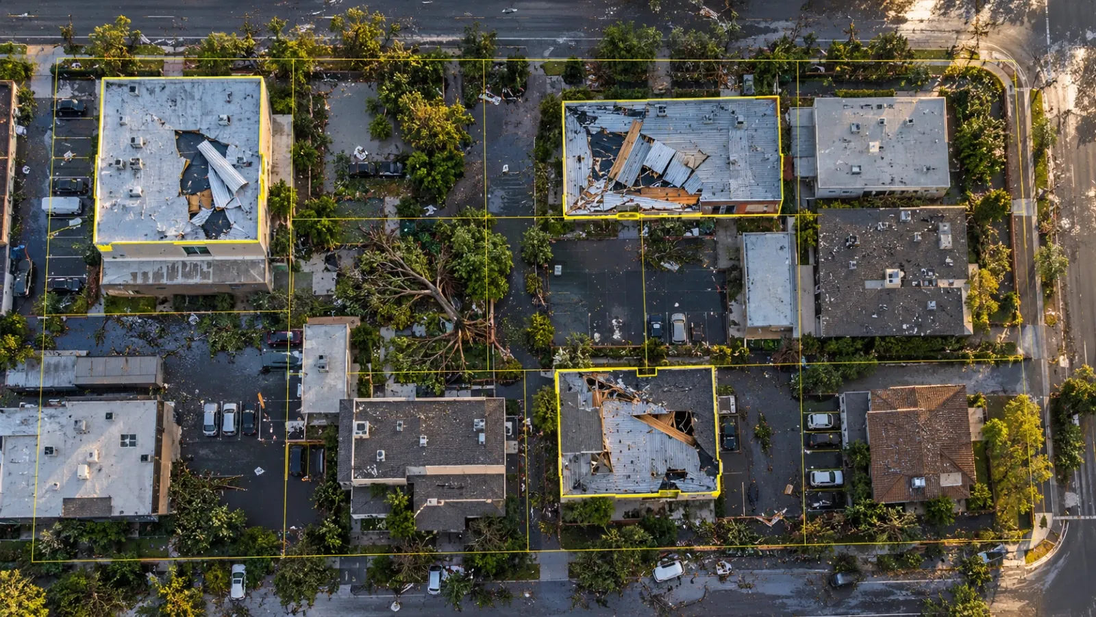
Drone damage assessment means surveying a building, site or portfolio from the air after an extreme event, so that the owner can see what was damaged, how badly and where, before committing people to unstable roofs, flooded ground or fire-weakened structures. The output is not a set of dramatic photos. It is a measurable, dated record that supports three decisions: what to make safe now, what to claim, and what to repair.
At YelloSKYE this work sits within Inspect IQ. The guide below is aimed at owners, facility teams and asset managers who may need to commission a survey after the next storm or flood. It covers what an assessment needs to answer, how each type of event shows up from the air, how to sequence the flights, how to build evidence an adjuster will trust, and how to turn findings into a repair scope.
What a damage assessment has to answer
After an event, everyone asks how bad it is. In practice an owner needs five separate answers, and the survey should be planned around them.
- Is it safe? Which structures can people enter, which areas need cordoning, and where are hazards such as hanging cladding, exposed cables or undermined slabs?
- What is the extent? How many buildings, how much roof area, how many facade panels, how much of the yard or car park is affected?
- How severe is each item? Cosmetic, functional, or structural?
- What did the event cause? Separating fresh damage from wear and older defects is usually the hardest part of any claim.
- What will it take to put right? Quantities, access needs and the order of work.
A drone survey answers the first two quickly, contributes heavily to the third and fifth, and is the best available tool for the fourth if an earlier capture exists.
Why look from the air first
The case for flying first is mostly about people. After an event, the most dangerous places on a property are often the ones you most need to see: roofs with lifted sheets, parapets that may fall, floors over a basement that flooded, and structures that have been through a fire. Sending someone up a ladder to count missing roof panels exposes them to the very failures you are trying to find.
Coverage is the second reason. A ground walk sees what is visible from paths and windows; a survey grid sees every roof plane, gutter and courtyard. On a large estate or campus, that completeness matters more than the detail of any single photo.
Speed is the third. Within days water drops, debris is swept and tarpaulins cover holes, so the early record is the one that shows the damage as the event left it. YelloSKYE's automated asset inspection work found drone capture made inspections 10x faster than scaffolding and rope access, and that difference is most valuable when time is short.
How different events show up from above
Each kind of event leaves a different signature, and the capture plan should follow it.
| Event | What the drone looks for | Most useful outputs | What still needs a person on site |
|---|---|---|---|
| Wind and storm | Missing or lifted roof sheets, torn membrane, displaced coping and flashings, fallen trees, damaged rooftop plant, broken glazing | Orthomosaic of all roofs, oblique photos of each elevation, measured areas of lost covering | Fixing condition, deck damage under remaining sheets, water entry inside |
| Flood | Water extent and debris lines, silt deposits, scoured ground, damaged drainage, displaced stock or vehicles in yards | Orthomosaic and terrain model, flood line marked against levels | Interior damage, contamination, electrical and plant checks |
| Fire | Collapsed or sagging roof areas, spalled concrete, distorted steel, scorch extent on facades, neighbouring exposure | Orthomosaic, 3D model, close oblique imagery, thermal to check for remaining hot spots | Structural engineer's assessment of fire-affected members |
| Earthquake | Cracked facades and parapets, fallen masonry, tilt or settlement, ground cracking, damaged services corridors | High-resolution facade capture, 3D model or LiDAR for tilt and deformation | Detailed structural inspection and any intrusive testing |
| Hail | Dented metal roofing, broken skylights, damaged solar modules, punctured membranes | Close-range grid imagery at fine resolution, thermal over solar arrays | Confirmation of membrane punctures by touch |
Two points apply to all of them. Resolution must match the damage: storm debris shows at almost any height, but hail dents and fine cracks need low, close flights. And the overview and the detail are separate flights; one pass rarely serves both.
Sequencing the response
A good assessment is staged: a useful picture within a day or two, then depth where it matters.
Stage 1: permission and safety
Disasters bring crewed emergency aircraft, and authorities often close the airspace around an incident to keep them safe. Those closures override any private survey, however urgent the claim. Flying regulations and the process for getting access differ by country, so check the notices issued by your national aviation authority (Transport Canada and Australia's Civil Aviation Safety Authority both publish them, for instance), and speak to the emergency services if they are still working nearby. On the ground, the take-off point needs to be clear of hazards and the pilot needs a safe line of sight to the area being flown.
Stage 2: the overview flight
The first flight covers the whole property on an automated grid at a moderate height. Processed into an orthomosaic, it gives one true-to-scale picture of every roof and open area. For a large site, split the area into sectors so that processing can start on the first sector while the rest is still being flown. This map supports the first decisions: where to cordon, where to start temporary works and which buildings to look at more closely.
Stage 3: targeted detail
Using the overview, mark the buildings and elements that need more. Fly those at lower height and from oblique angles to capture facades, parapets and the edges of roof damage. Add a thermal pass where moisture in a roof build-up or a remaining heat source is suspected; our guide to drone thermal inspection explains when the conditions allow it. Where deformation or tilt matters, LiDAR or a dense 3D model provides geometry that photos alone cannot.
Stage 4: ground follow-up
Engineers, adjusters and contractors then go where the record says they are needed, confirm what the imagery suggests and check what cannot be seen from outside.
Stage 5: repeat captures
Fly again after make-safe works, at key points during repair and at completion. Each capture closes a question: what was temporary, what was permanent, and whether the finished work matches the scope that was paid for.
The before picture
Most claims and repair disputes come down to the condition before the event. Without it, every crack and stain is open to argument over whether the storm caused it or whether it was already there.
The best before picture is a capture you already have. Owners who survey roofs and facades routinely, or who kept a construction-phase record of a newer building, can lay the post-event map beside the last one and point to what changed. In DEX, two capture dates can be viewed side by side, and our facade inspection from a desk use case shows the same comparison on individual elevations.
If no capture exists, assemble the next best evidence quickly: maintenance reports, earlier inspection photos, published aerial or satellite imagery, drawings and any images from tenants or neighbours. The guide to property condition assessment describes how a routine survey programme builds that baseline before it is needed.
For sites where water is the main risk, a terrain model also explains damage that photos cannot. Our flood risk and drainage planning use case uses drone terrain models and water flow simulation to show accumulation zones and drainage paths; the same model helps an owner understand why one end of a yard flooded and the other did not.
Building evidence an adjuster will trust
The claim process itself is covered in our builder's risk insurance claims guide. Here the point is narrower: what makes aerial evidence carry weight.
- Date and time. Every capture should carry its date, and the dataset should not be edited after the fact. Keep original files alongside processed outputs.
- Location. Georeferenced imagery lets anyone place a photo on the map. That stops arguments over which roof or which bay is shown.
- Scale. A measured area of lost roofing is more useful than a description. Controlled maps let the adjuster check quantities instead of estimating them.
- Comparison. One before and one after, captured the same way, is stronger than dozens of unrelated photos.
- Coverage. A complete map shows undamaged areas too, which helps credibility. Selective photos invite the question of what was left out.
- Access. Give the adjuster a link to the record rather than a drive full of files. Role-based access means they see what they need without wider project data.
Agree early with the adjuster what they want to see and in which format, so the first flight covers it.
From findings to a repair scope
Damage assessments are wasted if the findings stay as photographs. The aim is a scoped, priced and sequenced set of works.
Log each finding once, in one place
Each defect should be recorded at its location with an image, a measurement, a severity and a recommended action. Inspect IQ reports are built this way: every defect sits in a structured database with its GPS position, a marked-up image, a severity rating and a suggested remedy, and the register exports to PDF, Excel or a BIM-linked format. One register avoids the common problem of the insurer, the engineer and the contractor each working from different lists.
Separate make-safe from permanent repair
Temporary works such as tarpaulins, propping, fencing and boarding happen first and are often claimable in their own right. Record them separately so the permanent scope is not confused with what was done in the first week.
Measure, then price
Areas of lost membrane, lengths of damaged gutter, counts of broken panels and volumes of debris to clear can all be taken from a controlled map. Contractors still verify on site, but they price from shared quantities, which makes bids comparable. For roofs in particular, our guide to drone roof inspection explains how to triage defects and decide between repair and replacement.
Rank by consequence
Water entry into occupied space, loose elements over walkways and damage to fire or life-safety systems come before cosmetic repairs, regardless of how many cosmetic items there are.
Several sites at once
A regional event rarely damages one building. An owner with warehouses, schools or retail units across a region may need to know within days which ten of a hundred sites need attention first. The same method scales: fly a quick overview at each site, rank them by what the maps show, then send detail crews and engineers in that order. Keeping every site in one platform, as in our portfolio monitoring use case, lets a central team compare sites on the same terms instead of reading a separate report from each.
Handling the data responsibly
Post-event surveys produce large datasets quickly, often over neighbouring property and occasionally showing people's homes and belongings. Treat the data with the same care as any sensitive record:
- Keep raw and processed files in a controlled location, not on personal devices or messaging groups.
- Limit access by role, and log who opened or downloaded what.
- Blur or crop third-party property and people where imagery is shared beyond the claim.
- Agree retention with your insurer and legal adviser; claims and disputes can run for years.
Our guide to drone data security covers access control and storage in more depth.
What a drone cannot tell you
Aerial survey has firm limits after a disaster. It sees surfaces, not the condition inside walls, slabs or connections. It cannot confirm that a fire-exposed beam is still sound, that a flooded basement is free of contamination or that a cracked wall is stable. Thick smoke, high wind and heavy rain can delay flights. And the record supports a professional judgement rather than replacing it: a structural engineer still signs off on whether a building can be reoccupied.
The survey's job is to make the engineer's time count, by sending them to the right places with measurements already in hand.
A practical checklist
Before the next event:
- Capture a baseline of roofs, facades and grounds for each important asset, and repeat it on a regular cycle.
- Store the baseline where your team and your insurer can reach it quickly.
- Agree in advance who will fly, how quickly they can mobilise and how permissions will be handled.
After the event:
- Confirm airspace is open and the take-off area is safe.
- Fly a full overview first, then targeted detail and thermal where needed.
- Compare against the baseline and log each finding at its location with a measurement and severity.
- Record make-safe works separately from permanent repairs.
- Share one record with the adjuster, engineer and contractor, with access set by role.
- Fly again after repairs to close each finding with evidence.
Frequently asked questions
How are drones used for damage assessment?
A drone flies over the affected property or area and captures overlapping photographs, and sometimes thermal or LiDAR data, which are processed into a measurable map and 3D model. Owners, engineers and adjusters use that record to see the extent of the damage, decide where it is safe to send people, measure damaged areas and plan repairs. It replaces much of the first walk-round, though not the engineer's close inspection.
Can you fly a drone straight after a disaster?
Often, but not automatically. Authorities frequently restrict airspace over an incident area so that rescue helicopters and firefighting aircraft can work safely, and those restrictions take priority over any private survey. Check the current notices from your national aviation authority, coordinate with emergency services where needed, and fly only when the area is released or you have permission.
Will an insurer accept drone imagery as evidence of damage?
Drone imagery is widely used in property and construction claims, and adjusters increasingly ask for it. What makes it persuasive is the same as for any evidence: a clear capture date, a known location, enough resolution to show the damage, and a way to compare it with the condition before the event. Agree early with the adjuster what they need so you do not have to fly twice.
Can a drone see water damage inside a building?
Not directly. A drone records the outside of the building: roofs, gutters, facades, openings and the ground around it. A thermal camera can suggest where water has soaked into a roof build-up or wall, because wet materials hold heat differently from dry ones, but interior damage still needs a walk-through, moisture meters or 360° capture inside.
How soon after an event should a damage survey be flown?
As soon as it is safe and permitted, because evidence changes quickly: water recedes, debris is cleared and temporary repairs cover the original damage. A fast overview flight in the first days, followed by targeted detail captures, usually gives both a quick picture for decisions and the depth needed for the claim and the repair scope.