Preconstruction Planning: The Steps, the Outputs and Where Site Data Prevents Surprises
By Kush Agarwal, President and CEO, YelloSKYE. Published .
Executive Summary
- The Question: What does preconstruction planning involve, step by step, and how do you stop the site from overturning the plan once work starts?
- The Answer: Preconstruction runs from the brief to mobilisation: investigate the site, test buildability, estimate, programme, plan logistics and register risks. Most of the surprises that later wreck a budget come from existing conditions that were assumed rather than measured, so the site investigation step deserves the most attention.
- The YelloSKYE Angle: Survey IQ measures open ground and BIM IQ scans existing buildings before design is fixed, and Construct IQ records the baseline the construction phase is measured against, all held in the DEX platform.
Preconstruction planning is everything a project team does between deciding to build and putting the first machine on site: investigating the site, checking the design can be built, estimating cost, programming the work, planning logistics and agreeing how risk will be handled. Done well, it means the contract price and programme rest on facts rather than hope.
The hardest part is not the spreadsheet or the schedule. It is knowing the site well enough that nothing large is discovered after the price is fixed. That is where measured existing-conditions data earns its place, and where YelloSKYE's Construct IQ and Survey IQ fit. This guide sets out the steps, the output each one should produce, and the points where better site information most often prevents a costly surprise.
Where preconstruction starts and ends
Preconstruction begins once there is a brief and a site, and ends when the contractor mobilises. Within that window, cost and programme are still cheap to change: moving a building on paper costs a revision, moving it after the foundations are in costs a claim.
Who leads depends on the procurement route:
- Traditional (design, then tender, then build). The client's designers lead. The contractor prices a finished design and inherits whatever the design team found, or missed, about the site.
- Design and build. The contractor takes on design development and is responsible for buildability, so it carries more of the site risk and has more reason to investigate.
- Early contractor involvement or two-stage tender. The contractor joins during design to advise on programme, methods and cost, and the price is fixed once the information is good enough.
Whatever the route, the owner provides the brief, the budget and much of the site information. If that information is thin, every later step inherits the gap.
The steps of preconstruction planning
The steps overlap and loop back as the design develops, but each should leave behind a clear output.
| Step | Question it answers | Main output | Existing-conditions input |
|---|---|---|---|
| 1. Brief and constraints | What are we building, and what limits it? | Project brief, constraints register | Boundary, planning conditions, neighbours |
| 2. Site investigation | What is really on and under this site? | Survey and investigation reports | Topography, ground, services, existing structures |
| 3. Constructability review | Can it be built the way it is drawn? | Buildability comments, method statements | Access, levels, working space |
| 4. Estimating | What will it cost? | Cost plan or tender price | Measured quantities, earthwork volumes |
| 5. Scheduling and procurement | How long, in what order, and what must be ordered early? | Baseline programme, procurement schedule | Site constraints on sequence |
| 6. Logistics planning | How will people, plant and materials get in and move around? | Site logistics plan | Access points, space, crane positions |
| 7. Risk planning | What could go wrong, and who carries it? | Risk register, contingency | Everything above that is still uncertain |
| 8. Baseline record | What did the site look like on day one? | Dated pre-start survey and imagery | The site itself |
1. Brief and constraints
Write down what is fixed: the boundary, planning conditions, rights of way, protected trees, neighbouring buildings and any restrictions on working hours or traffic. A constraints register kept from the start stops the same issue being rediscovered at each design stage.
2. Site investigation
This step decides how many surprises arrive later. A sound investigation usually combines:
- A desk study of historic maps, previous uses, flood information and existing records.
- A topographic survey of levels, slopes, drainage paths, trees and structures.
- Ground investigation through boreholes and trial pits for soil, rock, groundwater and contamination.
- Utility detection to locate buried services and agree diversions with their owners.
- Existing building surveys where the project alters or sits against existing structures.
- Condition surveys of neighbouring property, so later damage claims have a reference point.
Several of these can only be done from the ground. The topography, drainage and above-ground features of an open site, however, can be measured from a drone flight in a fraction of the time, which leaves the ground team free for the work only they can do.
3. Constructability review
The constructability review asks whether the design suits the site and the methods available: whether a piling rig can reach the far corner, whether retaining walls can be built before the excavation beside them, whether the crane can lift the heaviest unit at the required radius. These questions are hard to answer on a blank plan and much easier on a measured model of the real ground.
4. Estimating
Estimators measure quantities from the design and price them. Two categories are especially sensitive to site data: earthworks, which depend on the difference between existing and finished levels, and temporary works, which depend on access, slopes and space. An estimate built on old contours can be wrong by a whole earthwork phase.
5. Scheduling and procurement
The baseline programme sets the sequence and durations, and the procurement schedule flags long-lead items such as transformers, structural steel, facade units and lifts. Site conditions shape the sequence more than many programmes admit: a single access point, a slope that must be cut before the frame can start, or a drainage outfall that needs a permit.
6. Logistics planning
The logistics plan decides where gates, haul routes, laydown, cranes and welfare will go at each phase. Draw it on a current, measured image of the site rather than a blank layout. We cover the method in detail in our construction site logistics plan guide.
7. Risk planning
Every step above produces uncertainties. The risk register records them, assigns an owner and decides whether to investigate further, price a contingency or transfer the risk by contract. Keeping that register tied to evidence once work starts is the subject of our construction risk management guide.
8. Baseline record
The last step before mobilisation is to record the site exactly as handed over: levels, features, neighbouring structures and access routes, all dated. This is the reference every later quantity, progress claim and damage dispute will be measured against.
Where existing-conditions data prevents surprises
Most expensive surprises in construction are not unknowable. They are conditions that were there all along but were assumed instead of measured. The table pairs common ones with the preconstruction check that catches them.
| Surprise during construction | How it shows up | Check that catches it in preconstruction |
|---|---|---|
| Ground levels differ from old drawings | Earthwork quantities and platform levels change | Current drone or ground topographic survey on the project datum |
| Boundary or encroachment issue | Footprint or access moved late in design | Boundary survey with the legal coordinates overlaid on a site map |
| Water collects where the design assumed it would drain | Ponding, revised drainage, delayed earthworks | Terrain model with flow analysis before drainage design |
| Existing building differs from its drawings | New steel or services do not fit | Laser scan and as-built model of the existing structure |
| Buried services in the way | Excavation stops, diversion costs | Utility detection survey and owner records |
| Access narrower or steeper than assumed | Larger vehicles and cranes cannot reach | Measured access route and turning areas |
| Neighbouring property damage alleged | Claims with no reference point | Dated condition survey and imagery before works |
Open ground
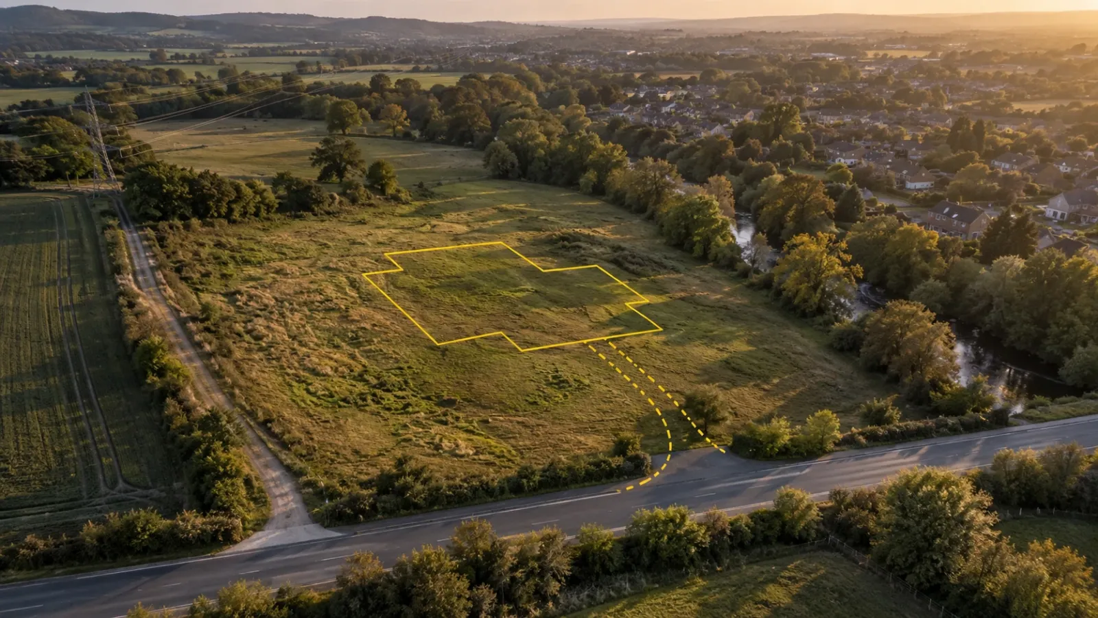
For land and greenfield sites, YelloSKYE's drone land survey for site feasibility produces boundary overlays, DEM and DTM terrain models, land cover classification, water flow simulation and a preliminary cut and fill estimate from one Survey IQ mobilisation, finishing the due diligence work 5× faster than a ground survey team would. Once a layout exists, terrain-based design validation places the CAD drawings on the drone terrain model, so mismatched levels and encroachments are resolved while design can still change.
Existing buildings
For refurbishment, extension and adaptive reuse, the existing structure is the main unknown. BIM IQ captures the building by laser scanning and turns the resulting point cloud into an as-built BIM model that designers and consultants can work from, an approach set out in the scan to BIM for renovation use case.
What site data does not do
Aerial and scan data describe surfaces. They say nothing about soil strength, groundwater or the exact depth of a buried cable. Those still need ground investigation and utility detection. Legal boundaries need a licensed surveyor. The aim is to measure everything that can be measured quickly, so specialist investigation is spent where it is truly needed.
Choosing how to capture existing conditions
| Site type | Main capture | Add where needed |
|---|---|---|
| Open land, greenfield, industrial platform | Drone survey with ground control | LiDAR under dense vegetation, ground survey for boundaries |
| Urban infill | Drone survey of the plot and neighbours | Laser scan of party walls and adjoining facades |
| Refurbishment or extension | Laser scan of the existing building | Drone survey of roofs and external areas |
| Linear scheme | Drone corridor mapping | Ground survey at crossings and tie-ins |
Whichever method you use, agree the coordinate system, accuracy and file formats with the design team first, so the data lands directly in their models. YelloSKYE surveys are delivered with sub-5 cm accuracy in plan and height in GeoTIFF, DXF, LAS and PDF formats. Our construction surveying guide compares the instruments in more depth.
Handing preconstruction over to the site team
The handover from preconstruction to delivery is where a lot of knowledge is lost. Estimators move to the next bid, and the site team starts with a programme and a logistics drawing but not the reasoning behind them.
A good handover passes on:
- the constraints and risk registers, with owners and open actions;
- the investigation reports and the measured site model;
- the assumptions behind the estimate and programme, so variances can be traced;
- the dated baseline record of the site;
- the logistics plan by phase, with the triggers for updating it.
From mobilisation, the baseline becomes the first entry in an ongoing record. Most Construct IQ projects have their first capture 48 to 72 hours after set-up begins, so there need not be a gap between the last preconstruction survey and the first progress capture.
Common preconstruction mistakes
- Pricing from old surveys. Contours from a previous owner or a public map rarely match the site today.
- Investigating late. Ground and utility surveys commissioned after the price is fixed only tell you how much you have lost.
- Leaving logistics to the site team. Access and crane decisions affect the programme and the price, so they belong in preconstruction.
- No baseline. Without a dated pre-start record, the first earthwork claim and the first neighbour complaint have nothing to be measured against.
- Treating the risk register as a form. A register that is filled in at tender and never reopened does not manage anything.
Preconstruction checklist
- Brief, budget and constraints register agreed with the owner.
- Topographic survey on the project datum, current and controlled.
- Ground investigation, utility detection and existing building surveys commissioned early enough to affect the design.
- Constructability review held on a measured model of the site.
- Earthwork and temporary works quantities checked against measured levels.
- Baseline programme and long-lead procurement schedule issued.
- Logistics plan drawn for each phase on current site imagery.
- Risk register with owners, actions and contingency.
- Dated baseline survey and imagery recorded before mobilisation.
- Handover pack passed to the delivery team.
Frequently asked questions
What is preconstruction planning?
Preconstruction planning is the work done between the decision to build and the first day on site. It covers site investigation, constructability review, estimating, scheduling, procurement, logistics and risk planning. Its purpose is to make sure the project can be built for the agreed price and time before anyone commits to mobilising.
What are the main steps of preconstruction?
Most teams work through the brief and constraints, site investigation, constructability review, estimating, scheduling and procurement, logistics planning and a risk register, then record a baseline of the site before mobilisation. The steps overlap and repeat as the design develops; they are not a strict sequence.
Who is responsible for preconstruction?
It depends on the procurement route. Under a traditional contract the client's design team leads and the contractor joins at tender. Under design and build or early contractor involvement, the contractor's preconstruction manager leads estimating, programming and buildability with the designers. The owner remains responsible for the brief, the budget and the site information it provides.
How does drone data help in preconstruction?
A drone survey gives estimators, designers and planners a measured, current model of the site: levels, slopes, drainage paths, access, vegetation and neighbouring structures. That replaces assumptions taken from old maps and makes earthwork, access and logistics decisions more reliable. It does not replace ground investigation, utility detection or a legal boundary survey.
How long should preconstruction take?
There is no fixed length. A simple building on a known site may need a few weeks; a complex infrastructure or refurbishment project can need many months of investigation and design. The useful test is whether the main site risks have been investigated and priced before the contract sum and programme are fixed.