AI vs Manual Progress Verification in Construction: Cost, Accuracy and Speed Compared
By Kush Agarwal, President and CEO, YelloSKYE. Published .
Executive Summary
- The Question: Is AI-assisted progress verification actually cheaper, more accurate and faster than an engineer checking the site by hand, and when is it not?
- The Answer: Software wins on coverage, consistency, measurement and the time between a site condition and a decision. People win on judgement: quality, cause and sign-off. Manual-only checking looks cheap because its biggest cost, finding problems late, never appears on an invoice.
- The YelloSKYE Angle: Construct IQ captures the site on a fixed routine, and DEX aligns each capture with your drawings and schedule, flags deviations and calculates volumes, so engineers spend their time reviewing findings rather than collecting them.
AI-assisted progress verification captures the site on a routine with drones, fixed cameras and 360° cameras, then uses software to line each capture up with the design and programme and flag the differences for an engineer to review. Manual verification relies on a person walking the work and recording what they judge to be finished. Set side by side, the AI-assisted approach is faster, covers the whole site instead of a sample and measures quantities instead of estimating them. Manual checks remain better at deciding whether work is acceptable and why a zone is behind.
This guide compares the two on the three things project directors ask about first: cost, accuracy and speed. It uses examples from how YelloSKYE verifies progress through Construct IQ, our construction monitoring solution. It does not explain the mechanics of capture and processing step by step; our guide to automated construction progress tracking does that.
Two ways of answering "how far along are we?"
Every progress claim, programme update and owner report rests on one verification step: confirming that the work described actually exists on site. The two approaches share that goal. They differ in who does the looking, how much of the site gets looked at, and what form the answer takes.
Manual verification
A site engineer, quantity surveyor or project manager walks the work, compares it with the drawings and the claim, and records a judgement: a percentage, a tick against a milestone, a line in the daily report. Where measurements are needed, they come from a tape, a total station or a survey crew booked separately. The output is one person's assessment, usually written up after the walk.
AI-assisted verification
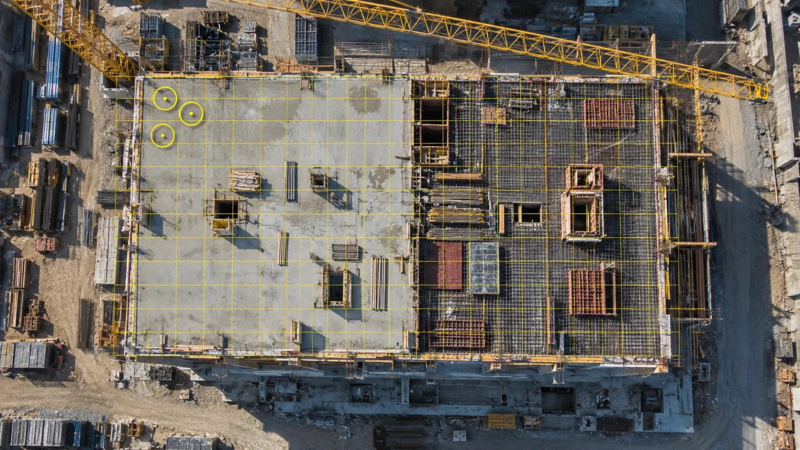
Capture follows a set routine: drone flights over the site, fixed cameras on chosen zones, 360° walks through the interiors. Software turns the imagery into maps, models and navigable views, places each capture against the CAD or BIM model and the schedule, calculates quantities such as cut and fill, and marks where the site differs from the plan. An engineer then works through those marks. The output is a dated, measurable record plus a short list of exceptions.
"AI" covers a lot of ground in vendor material, so it is worth being precise. In YelloSKYE's case it means the processing in DEX that aligns captures with your models, flags deviations, calculates volumes and updates the progress dashboard. It does not mean a system that certifies workmanship or approves a claim by itself. Be cautious of any provider that implies its software does.
Accuracy is really four separate questions
Asking which method is more accurate gets you nowhere until you split accuracy into its parts. Each method is strong on different ones.
| Accuracy question | Manual verification | AI-assisted verification |
|---|---|---|
| Coverage: did we look at all of it? | A sample: the areas the engineer reached and chose to inspect | Every captured area, every cycle, from the same routes and viewpoints |
| Measurement: how much is there? | Judged by eye, or measured by a separate survey that can take weeks to arrange | Calculated from the capture data; YelloSKYE's drone-derived volumes are within 1 to 3 per cent of a conventional ground survey |
| Consistency: would two reviewers agree? | Often not; the figure depends on the person and the time they had | The same processing runs each cycle, so a change in the figure reflects the site rather than the reviewer |
| Judgement: is it acceptable, and why is it late? | Strong, when the engineer is experienced and present | Weak; imagery shows what is in place, not whether it meets specification or what held it up |
How manual figures go wrong
The usual faults are sampling and rounding. An engineer with two hours on a large site inspects the zones that look busy or contentious and infers the rest. Partly finished work tends to be credited generously, particularly when the person reporting also wants the claim paid. None of this needs bad faith. It is what happens when one person must judge a large, changing site quickly. Our guide to percent complete in construction shows how these small differences add up once activities are weighted into a project total.
How AI-assisted figures go wrong
Automated processing can misread cluttered or unusual scenes, and imagery cannot see behind closed walls or tell you whether a pipe has passed its pressure test. Positional accuracy also depends on how the data was captured. YelloSKYE flies RTK-GNSS drones with ground control points to reach sub-5 cm positional accuracy; a drone flown without control will not match that. These limits are the reason automated output should be reviewed before anyone acts on it, and why YelloSKYE pairs its processing with civil and geospatial engineering review.
Speed: the lag between the site and a decision
Speed is not how quickly someone can walk a floor. It is the time from a condition appearing on site to the right person deciding what to do about it. That lag has four stages, and the two methods spend very different amounts of time in each.
| Stage | Manual verification | AI-assisted verification |
|---|---|---|
| Capture | Whenever someone can get to site, often only before each claim | On a fixed schedule: drone flights weekly or fortnightly, fixed cameras running throughout |
| Compile | Notes and photos retyped into a report and a spreadsheet | Imagery processed into maps, models and dashboards with no re-entry |
| Compare | An engineer reconciles the report with the programme and the claim | Captures checked against the 4D schedule and the CAD or BIM model, with deviations flagged |
| Decide | Findings raised at the next progress meeting | Everyone opens the same dashboard; alerts can fire when a milestone is reached or work stops in a priority zone |
The difference shows up in how a team's week is spent. When one developer moved to a weekly drone programme, described in our aerial progress capture use case, its site managers recovered over 15 hours of reporting time each week and stakeholder reviews went from two hours to half an hour. On earthworks, the earthwork volumetric analytics use case describes survey turnaround dropping from two weeks to a few hours once drone topography replaced manual survey cycles.
Speed matters at the start of a project as well. On most Construct IQ projects, set-up and the first capture are complete inside 48 to 72 hours, so a measurable record can exist before the next claim date rather than after the first disagreement.
Cost: what you pay now and what you pay later
Cost comparisons usually go wrong because the costs of manual verification are scattered across salaries, travel and late surprises, while an AI-assisted service arrives as one visible line in the budget.
| Cost item | Manual verification | AI-assisted verification |
|---|---|---|
| Senior staff time | Engineers walking, measuring and writing up every cycle | Engineers reviewing flagged exceptions instead of gathering data |
| Travel | Rises with the number of sites and the distance between them | Routine checks happen from the desk; visits are made with a purpose |
| Survey crews | Called in for quantity disputes and earthwork measurement | Volumes come from the routine drone captures |
| Capture service and platform | Nil | Flights, cameras, processing and platform access |
| Finding problems late | Over-payment, rework and disputes surface weeks after the cause | Reduced, because deviations are flagged in the cycle they appear |
| Settling disagreements | Argued from memory and partial photos | Resolved against one shared, dated record |
The cost that never reaches an invoice
The largest line in that table is the one nobody budgets for. When a claim is certified on an estimate, the over-payment sits with the contractor until someone notices, which may be months later. When a misplaced element is found only after the next trade has built around it, the repair includes taking out good work as well as fixing the original fault. Manual verification is not expensive to run. It is expensive in what it fails to catch, and in how late it catches the rest.
How each approach scales
Manual effort grows roughly in step with site area and the number of sites, because someone has to walk each one. AI-assisted capture grows too, but the review effort grows far more slowly, because engineers look at exceptions rather than at everything. That is why the gap is widest on portfolios. In our portfolio monitoring use case, leadership now checks 10+ sites in half an hour from one dashboard, because each site is captured with the same drone, 360° and fixed-camera settings.
Matching the method to the project
Neither approach is right everywhere. The table below is a starting point for deciding the balance.
| Project situation | Lean towards | Reason |
|---|---|---|
| Short fit-out on a single floor with few trades | Mainly manual, with 360° records at key stages | Small area; judgement matters more than coverage |
| Large site with heavy earthworks | AI-assisted, led by drone survey | Volumes drive the claims and can be measured from the air |
| Multi-storey building during structure | AI-assisted for progress, manual for quality | Drones and fixed cameras follow floor cycles; inspections confirm the work |
| Interior services and finishes | A balanced mix | 360° capture shows what is installed; testing and commissioning need people |
| Road, rail or pipeline over many kilometres | AI-assisted | Walking the full length every cycle is not practical |
| Several active sites under one owner | AI-assisted with a standard capture setup | Comparable baselines matter more than any single walk |
Where manual checking still earns its place
There are jobs that software does not do, and a verification plan should name them rather than assume they are covered.
- Quality and specification. Whether the work meets the standard, not only whether it exists.
- Hidden and tested work. Pressure tests, concealed fixings and commissioning results need certificates or a person present.
- Cause. Finding out why a zone stalled usually means a conversation with the foreman, the supplier or the designer.
- Formal sign-off. Certified levels, statutory inspections and legal boundaries stay with qualified professionals.
- Working relationships. A visit to a struggling subcontractor can change how a package is run in a way a dashboard cannot.
The goal is not to take engineers off site. It is to stop sending them there only to find out how far the work has got.
Testing both methods on your own project
Vendor figures, ours included, are a weak basis for this decision. A short side-by-side trial on a live package gives you numbers from your own work.
- Choose one package with real money at stake. Earthworks, the frame or a large services package all work well.
- Run both methods for three claim cycles. Leave the manual process unchanged and add routine capture timed to the same cut-off dates.
- Log the hours. Record time spent walking, measuring, compiling and meeting under each method.
- Compare the figures. For each claim item, note the manual figure, the figure the capture supports, and the gap between them.
- Note what was found and when. For every deviation, record which method spotted it first and how many days earlier.
- Count the disagreements. Track how many items were disputed and how long each took to settle.
After three cycles you will know what each approach costs and catches on your project. Teams that time drone captures to their billing cycles, as in our contractor billing use case, have needed 80 per cent fewer site visits to verify claims.
Checklist: setting your verification mix
- List every decision that depends on verified progress: payments, programme updates, owner reports and delay claims.
- For each one, decide whether it needs measurement, coverage, judgement or all three.
- Give measurement and coverage to routine capture and software; keep judgement and sign-off with people.
- Schedule a capture just before every claim cut-off.
- Name a reviewer for every automated output, so flags are read and acted on.
- Agree in writing what "complete" means for key activities before the first capture.
- Revisit the mix when the project moves from structure into interiors, because the right capture method changes.
For how verified progress then feeds reporting, payments and dispute records across a whole project, see our guide to construction progress monitoring.
Frequently asked questions
Is AI progress verification more accurate than a manual site walk?
It depends on what you mean by accurate. AI-assisted verification covers the whole captured site every cycle, measures quantities from the data and gives the same result whoever reviews it, so it is usually more accurate on coverage, measurement and consistency. A manual walk by an experienced engineer is still better at judging whether work meets specification and why it is late.
Does AI-assisted progress verification replace site engineers or quantity surveyors?
No. It replaces the routine collecting, measuring and compiling that takes up much of their week. Engineers still review the flagged deviations, check quality, investigate causes and sign off claims. The difference is that their site visits have a purpose rather than being made only to find out how far work has got.
Is AI progress verification worth it on a small project?
On a short, single-floor fit-out with a few trades, a manual process with 360° records at key stages is often enough. The case for AI-assisted verification grows with site area, the number of sites, the value of each claim and how much of the work can be measured, such as earthworks and structure.
Can AI-verified progress be used to approve contractor payments?
Yes, provided the capture is timed to the claim cut-off and an engineer has reviewed the output. The contractor, project manager and owner then check the claim against the same dated, measurable record. For earthworks, volumes calculated from drone surveys let the team check claimed quantities without commissioning a separate resurvey.
What do you need to start AI-assisted progress verification?
You need the current programme, drawings or BIM models to compare against, and an agreed capture plan covering zones, cadence and claim dates. The capture itself can be done by the provider's pilots or your own site team. With YelloSKYE Construct IQ, most projects are set up and first captured within 48 to 72 hours.